Pentland to Portobello Route
Pentland to Portobello Route
A feasibility study has been produced which aims to establish a route which runs from the base of the Pentland Hills to Portobello on the coast in Edinburgh. The aim of the project is to enable people to travel predominantly off-road from the city to the countryside and create a green active travel corridor for the south east which would …

A feasibility study has been produced which aims to establish a route which runs from the base of the Pentland Hills to Portobello on the coast in Edinburgh. The aim of the project is to enable people to travel predominantly off-road from the city to the countryside and create a green active travel corridor for the south east which would mirror the fantastic Water of Leith walkway. Full report: 50286 Feasibility Report 19.06.19
The route will follow the Burdiehouse Burn which starts near Swanston at the foot of the Pentlands, running through Liberton and Gilmerton, passing the Edinburgh Royal Infirmary and Niddrie before arriving at the North Sea at Joppa. The route is approximately 14km and will link into other pathways and routes that include the John Muir Way. The route is shown below in the following sections.
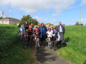
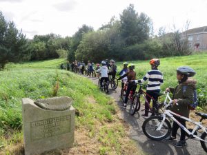
The idea of walkways along Edinburgh’s waterways was first raised in the 1940s, and since then the long term ambitions for a Water of Leith Walkway have been implemented, but progress on smaller watercourses like the Burdiehouse Burn have not progressed. The vision for a new strategic pathway has been developed by the Friends of Burdiehouse Burn to connect the park with the surrounding areas and to provide a link for active travel and wildlife.
The study on the route was funded by Sustrans and CSGNT Development Fund, and was carried out by leading environmental consultancy Ironside Farrar. It investigated how the proposed route will improve active travel leading to the further development of green networks and improve access to greenspace. By extending active travel routes the network will contribute towards the SESplan Strategic Cross Boundary Cycle Development plan and provide links between Midlothian, Edinburgh and East Lothian through proposed routes at Newcraighall and Musselburgh.
The proposed route links Edinburgh City Bypass at Frogston Road and the study reviewed the existing junctions in more detail and provided options which will involve improved signage.
Opportunities also exist to tie in with developments around Gilmerton Station Road, linking in with the old railway path to Shawfair and the potential to provide a safe quiet route for the A701 corridor with Bush Estate to Kaimes along the Pentland Burn.
The project will help disadvantaged communities, including the bottom 5% of SIMD, giving increased access to greenspace and enabling them to enjoy nature on their doorstep. It will also encourage people to improve their health and well-being through physical activity and enjoying nature. Future delivery of the route will provide the opportunity for local communities to be involved in the looking after of their local environment through volunteering and community action that will generate greater local and civic pride.
The route will also help foster economic development and help spread the benefits of tourism beyond Edinburgh’s city centre. Cycling is one of the fastest growing leisure pursuits and the south of Scotland has seen huge benefits from cycling. The proposals will be enhanced through the development of promotional material for a range of historic features and attractions in the south of the city, with the intention being to help link up with existing facilities to encourage visitors. The Friends of Burdiehouse Burn has worked in partnership with the historic Gilmerton Cove to help raise awareness of the heritage in the area.
At the centre of the proposed pathway is Edinburgh Royal Infirmary and the Edinburgh BioQuarter. The proposals will create off road routes to work for the many thousands of people working in the largest concentration of employment in south east Edinburgh, which will help alleviate congestion and further improve health.
Through funding from the Nature Restoration Fund, green infrastructure aims to create green corridors and improved biodiversity which will help deliver an integrated habitat network across the region by joining up important nature reserve sites with green and blue habitats. Burdiehouse Burn Valley Park is a local nature reserve, as are the nearby Straiton Pond and Hermitage of Braid and Blackford Hill. The route will help link these important sites as well as the Pentland Hills themselves of course.
It’s exciting to help launch the Pentland to Portobello Active Travel Project, and its vision of an accessible active travel link for the south east of Edinburgh. This study reflects the Council’s aims to encourage cycling and walking as enjoyable and healthy modes of transport by providing safe, welcoming routes, connecting new and existing developments Councillor Lesley Macinnes, Transport & Environment Convenor of the City of Edinburgh Council
Funded by: Sustrans, CSGNT Development Fund
Outputs:
• Define the total length of the route which will be broken down into different sections.
• Determine how it would link up with existing active travel routes to fit with the citywide network. This will involve working with the local authority, SPOKES and other active travel organisations. This will include additional signage for the network and ensuring the points of interest along the route link with the different neighbourhoods. It will also establish how it links with safer routes to schools.
• Identify options for dealing with the connections with infrastructure and who needs to be involved and the process and timescales.
• Determine the benefits to wildlife through green networks by providing an ecology report.
• Engage with the different owners of the land along the route.
• Determine the timescales of current housing developments and who would be involved.
• Deliver community engagement activities with the local groups along the route to ensure they are involved in the design process.
• Determine the health benefits especially for areas of disadvantage by increased access to active travel routes.
• Investigate the potential opportunities to help the area adapt to climate change.
• Determine the potential economic benefits the route would have on improving the appearance of the route and what the opportunities are for increased tourism to the area.
Outcomes:
• enable the key stakeholders to participate and have greater control on the development of green infrastructure
• raise awareness of the importance that green networks are to the local wildlife
• promote the active travel network and how it can link up with other areas in the city to encourage greater use of off road paths.
• providing opportunities for communities to come together and take part in community engagement activities.
• better understanding of the what are the key uses and links to local assets that the route could provide
• what are the potential economic benefits to creating the strategic routes.
• where the opportunities are to increase accessible greenspaces in the area.